 |
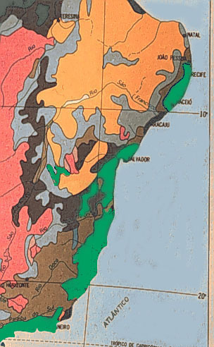
The green areas represent the original extent of the Atlantic coastal forest. The tropical coastal forests can be divided into three distinct regions:
- the forests of the states of Rio de Janeiro and São Paulo (lowest green area on map),
- those of the states of Bahia and Espírito Santo(long green area in center portion of map), and
- those of the small states of northeasternmost Brazil (small green area at top of map).
As one moves inland in Bahia, the vegetation becomes increasingly dry. Inland Bahia has a complex interdigitation of two important Brazilian vegetation types, the Cerrado (pink on the map) and the Caatinga (orange-yellow on the map). The Cerrado is the prairie/savanna vegetation that dominates central Brazil. The Caatinga is the dry thorn scrub that is the dominant vegetation type in the interior of northeastern Brazil. |